|
Along the South Downs Way
Craig Roberts travels through spectacular downland scenery from Winchester to Eastbourne, past ancient hill forts, stately homes and famous seaside resorts.
From the open downland of Old Winchester Hill in Hampshire to the chalky cliffs of Beachy Head on the East Sussex coast, the South Downs provides as diverse a landscape as one could wish for and a favourite beauty spot for people living in London and the congested South East. With its steep valleys and curvaceous slopes, the downs offer riders and walkers alike extensive views plus the chance to get away from it all.
Now the Downs have become England’s 9th National Park, 60 years since it was first recommended and now ranks alongside the Lake District, Brecon Beacons and Dartmoor. It also joins its nearest neighbour, the New Forest that was given status in 2005. It fits in nicely as an alternative to the hills and mountains of its new cousins, as a gentle rolling landscape with an abundance of wildlife. Among the important species now protected are Bechstein’s bats and rare woodland butterflies like woodland white and dark green fritillary.
The word ‘downs’ comes from the Celtic word dun, meaning hill or fort and sets to remind of the Celtic era of rule. Since then, the rolling hills have seen attack from Romans, Saxons and Normans, largely due to its close proximity to the Continent.
Running through the south of England, gives it advantage to warm and mild conditions. Yet on a foggy, winters day it can be as cold and as bleak as the hills of the north. Throughout history it has provided man with rich agriculture land on which to work. Introduced by Stone Age man, the rolling downs were ideal for sheep grazing with corn growing on the slopes below. Since the Second World War though, arable crops, through modern farming practises, have replaced much of the downland grass.
Water is also prominent in its beauty, with several rivers cutting their way through the downs. These include The Arun, Ouse, Adur and Cuckmere.
Starting in the west on the edge of historic Winchester, the new park takes in Harting Down on the Sussex border and the village of South Harting. This was once home to the naturalist Gilbert White, as well as the author Anthony Trollope, the man who introduced pillar-boxes to Britain. This part of Hampshire has an abundance of pretty villages like Alresford, East Meon, and Hambledon, a village that is revered as the cradle of cricket and certainly had a major part in increasing the popularity of the sport.
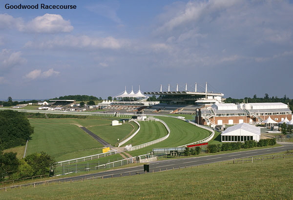
Heading into the Sussex countryside, the downs act as stunning backdrop over the Goodwood Estate. This splendid estate incorporates the country park, house and the racecourse itself. Synonymous with ‘Glorious Goodwood’, “A garden party with racing tacked on” as King Edward VII described it, which is held each July. This grand event was first introduced in 1802 when the Duke of Richmond would race his horses there. The racecourse is arguably the most spectacular looking, sitting in its own natural amphitheatre and the motor racing circuit in the grounds of the house was used for racing between 1948 and 1966.
The park travels on down to the Arun valley, offering extensive views of the Weald and English Channel along the way. It crosses over the River Arun, which itself runs through the delightful Sussex town of Arundel.
Sadly, this historic market town has been left outside the boundary of the park, which is a shame as it’s such a beautiful and unique place dominated by its castle and neo-Gothic cathedral. It’s still well worth visiting if exploring the downs, especially in June for the Festival of Corpus Christi, when the nave of the Roman Catholic cathedral is laid with a carpet of around 30,000 flowers and provides a marvellous spectacle.
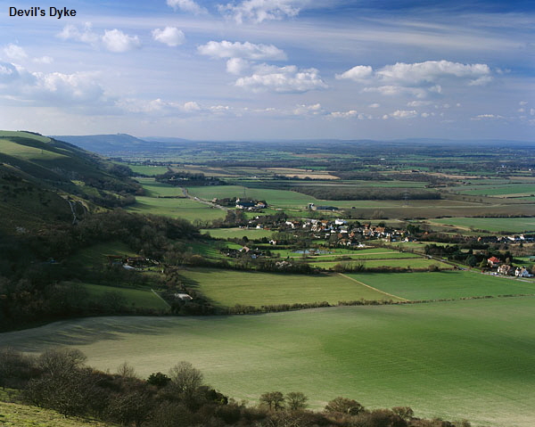
After passing through the Iron Age hill forts of Cissbury and Chanctonbury Rings, the downs cross the River Adur and run north of the coastal towns of Worthing and Brighton. Here it meets Devils Dyke with its hotel and fantastic views. The legend goes that this deep, dry valley was made by the devil. Enraged at the number of churches in Sussex, he was attempting to flood them with the sea. He had almost finished cutting the downs, but was disturbed by a woman holding a candle, which he mistook for the dawn. As he could only work at night he left with his work unfinished. It became one of the most popular excursions in Victorian times and still is today. Hang-gliders now use it for their launching sites, taking long strides down hill before leaping off into the open valley below.
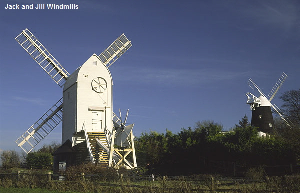
Further east are the two windmills known as Jack and Jill. Jack, the black one was built in 1866 and is now privately owned. Jill is a white post-mill and was built in Brighton in 1821, before being pulled to the hill top location some thirty years later by oxen. She is open in the summer and still grinds flour to this day.
Ditchling Beacon is the third highest point on the downs and like Devils Dyke offers grand views of the park across Sussex. Its name comes from a time when it was one of a chain of beacons across the South of England, used to signal an attack.
The park passes north of Brighton one of the UK most popular seaside resorts. It is also the largest town in Sussex and affectionately known as ‘London by the sea’, it was made fashionable by the Prince Regent.
Heading into East Sussex we reach the county town of Lewes. Situated on a spur of the downs on the bank of the River Ouse the town was close to being excluded from the park boundary, but support from 20,000 postcards being sent to Defra and backing by author Bill Bryson, saw it rightly included in the final plans along with Ditchling and the Western Weald. Its naturally defensive position made it an important place in Saxon times. After the Conquest, William de Warrene built the famous castle that dominates the town. The castle was taken in 1264 by Simon de Montfort who defeated Henry III and forced the King to sign a treaty that marked the beginning of parliamentary government in England.
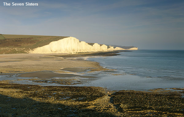
The route now heads towards the coastal town of Eastbourne, passing over the snaking Cuckmere River that heads out to sea at Seven Sisters and the nearby Beachy Head.
The whole part of this area, from Seaford to Eastbourne, was the first ever stretch to be designated as a Heritage Coast.
Beachy Head rises to 536ft above the English Channel and lighthouse below. The name is derived from the French beau chef, meaning beautiful headland. The lighthouse below is made of Cornish granite and was built in 1902. It has been automatic since 1983 and casts its beam up to twenty-five miles away.
The parks eastern boundary is at Eastbourne, affording magnificent views of the town on the way. Eastbourne grew up under the patronage of William Cavendish, 7th Duke of Devonshire who owned most of land and is the youngest of the south coast resorts.
The town started developing in 1851 around the 12th century church of St. Mary, and like Brighton, became fashionable after a royal visit by the children of George III.
The South Downs National Park has an unmistakable charm and is steeped in history, which can be appreciated by all ages. Whether taking a Sunday afternoon stroll, or by visiting one of the historic towns along its way, remember the words of Kipling, who, in his poem almost predicted the outcome of the South Downs as a National Park.
The Weald is good, the Downs are best
I'll give you the run of 'em, East to West.
Rudyard Kipling
'The Run of the Downs'
All images and text copyright © Craig Roberts 2000
|